Author Topic: Rancho Corral de Tierra December 30, 2013  (Read 91563 times)

Skyline35

  • Mudders
  • **
  • Posts: 109
Rancho Corral de Tierra Interim Trail Plan
« Reply #40 on: May 06, 2014, 03:36:34 PM »
Wow, a lot of information in this latest report!
Yes, MunNCrud is the number one source of information on the internet!

Glad that we rode the Old Colma Bike Road when the ride could still go through.
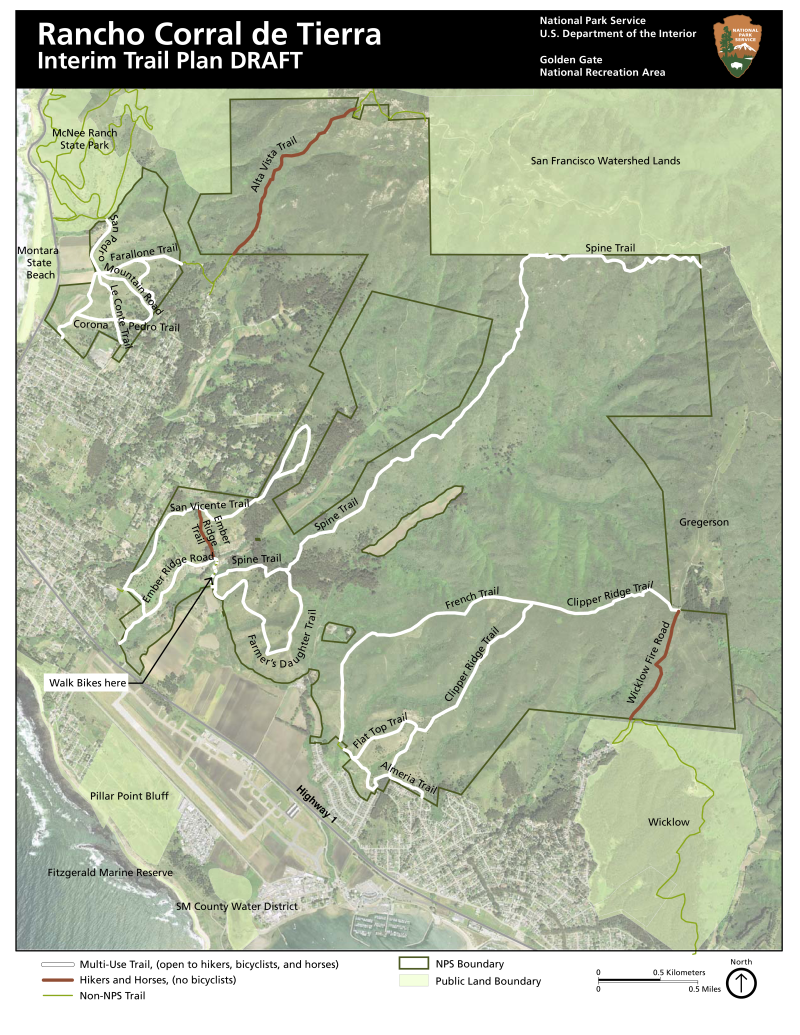
You will need to go try the Alta Vista Trail now before it becomes off-limit to bikes. More news....released today:

Rancho Corral de Tierra Interim Trail Plan


Introduction

The National Park Service (NPS) is developing an Interim Trail Plan for Rancho Corral de Tierra (Rancho) in San Mateo County, which is part of the Golden Gate National Recreation Area (GGNRA). The 3,800-acre property was acquired by the National Park Service in December 2011 from the Peninsula Open Space Trust (POST). Rancho is home to many informal trails that have evolved over time, prior to NPS acquisition of the property. Rancho is rich in natural resources and ideally situated to provide a variety of recreational opportunities.

When NPS acquired Rancho, trail use designations were established per current use of the park taking into consideration a variety of factors related to the presence of sensitive resources, safety, and existing conditions of the rails. These uses have been in place since December 2011. This project will establish the official Interim Trail Plan for Rancho until a Long-Range Trail Master Plan is completed in the next three to five years. GGNRA will conduct environmental compliance for the Interim Trail Plan, which will confirm uses including hiking, bicycling, and horseback riding, for the designated network of existing trails. This will include a public review and comment period. The Interim Trail Plan does not address or regulate dog walking activities and defers to the Dog Management Plan.

Once the Interim Trail Plan is established, NPS will begin to develop a more comprehensive Long-Range Trail Master Plan, which will build upon the Interim Trail Plan, identify opportunities for new trail connections and networks within the property and with adjacent lands, and reevaluate permitted recreational uses for each trail segment. The Long-Range Trail Master Plan will include extensive public outreach, coordination with partner agencies, and long term visioning for future uses of this property. NPS intends to prepare this document in the next three to five years. In addition, NPS will begin environmental compliance on two new trail head locations to provide public access to Rancho. The proposed trail heads will be incorporated into the Long-Range Trail Master Plan but will be standalone projects with their own public outreach schedule.  

Purpose

The purpose of the proposed plan is to confirm a well-functioning network of trails, identify which trails will be maintained by the NPS, minimize use of and establishment of social trails, and to enhance experience of  Rancho while preserving the area’s resources. These goals are in line with the 2014 General Master Plan (GMP), which stresses the importance of providing diverse recreational opportunities heavily reliant on a system of trails (GMP, 1:S-ii). The Interim Trail Plan would also provide guidance for the management of trails in Rancho until the LongRange Trail Master Plan is completed. For the Interim Trail Plan to be successful, it must meet the following objectives:

• Improve the efficiency of trail management by identifying and designating official trails for use by visitors
and maintenance by the NPS.
• Establish official trails names to aid park visitors and improve management.
• Assign acceptable uses for trails to avoid conflicting uses or improper use of park land.

Need

Present conditions include a vast network of informal trails that receive frequent use by the local community as well as a growing number of new users. The Rancho trail network is an inherited system of informal trails that were not planned and received minimal maintenance prior to NPS management. Many of the trails are steep and eroding, and in need of improvements and/or realignment. The Interim Trail Plan proposes to recognize 16 miles of trails that will be maintained at Rancho which will allow for strategic trail management. Prior to becoming part of the GGNRA, Rancho was managed by POST, which maintained use restrictions but was unable to enforce compliance. This resulted in conflicting trail uses within the park in an unmanaged capacity. This plan will help mitigate these conflicts by establishing accepted trail uses (bicycle, pedestrian, and equestrian use).  

Project Objectives

The Interim Trail Plan is intended to serve as the approved plan for the property for the next three to five years. Once completed, the Long-Range Trail Master Plan will replace the Interim Trail Plan. The management objectives for the plan are intended to:  

• Build public awareness on the appropriate use of the site, and protect habitat from unauthorized and/or destructive use.
• Build public awareness on the unique values and recreational opportunities.
• Reduce conflict and safety concerns raised by shared use of trails.
• Ensure access throughout the site without compromising slope stability or sensitive habitat.
• Establish trail names to be recorded on trail maps, brochures, and websites.
• Establish trail network to be maintained by the NPS trail crew.

In developing this plan, the NPS has gathered public input on trail locations, names, and uses during a public open house and informal neighborhood gatherings, and continues to seek public input on the Rancho Interim Trail Plan through June 14. The proposed trail locations, names, and permitted uses account for a variety of trail experiences while protecting park resources. Your input is requested on the following:
 
 
• Trail network to be maintained by the NPS. Do the maps accurately reflect the trails most used by visitors? Are there additional trails not shown on these maps that are frequently used?

• Designated trail names to be recorded on maps, brochures, and websites. Are the proposed trail names consistent with local designations? Are there alternate names that are used, or proposed names that should be considered?  

• Proposed permitted use. Please review the attached map, and provide specific feedback on the range of trail uses. Some trails are proposed to be multi-use (bicycle, pedestrian, and equestrian), while others would restrict bicycle use (pedestrian and equestrian only) because of safety, user conflicts, and access.

mudworm

  • Head Mistress
  • *
  • Posts: 1723
    • http://www.mxi2000.net
Re: Rancho Corral de Tierra Interim Trail Plan
« Reply #41 on: May 06, 2014, 08:59:54 PM »
Yes, MunNCrud is the number One(?) source of information on the internet!
You will need to go try the Alta Vista Trail now before it becomes off-limit to bikes.

Not sure I want to after I read "As for Alta Vista, 'It doesn't seem like much fun, you'd just be riding the brakes the whole time' which I thought was an accurate assessment. "

I did read your report carefully.
Inch by inch, I will get there.

mynameismud

  • unworthy
  • Posts: 5974
    • Mudncrud
Re: Rancho Corral de Tierra December 30, 2013
« Reply #42 on: May 07, 2014, 05:54:19 AM »
well at least not to many bicycle closures although closing the Wicklow fire road to bicycle seems a bit senseless. 
Here's to sweat in your eye

mudworm

  • Head Mistress
  • *
  • Posts: 1723
    • http://www.mxi2000.net
Re: Rancho Corral de Tierra April 30, 2014
« Reply #43 on: May 09, 2014, 10:12:32 AM »
Now for some disappointment, the staircase up to the tunnel tailings landfill has been removed:

Hi Charlie, how is the backtracking of Old Colma Rd? Is it equally fun (since I've never ridden in that direction)? I'm thinking about showing two friends (one from out of town) Montara riding, and want to show them the best. But usually, out and backs are avoided unless it's nice both ways. I don't remember anything super steep going town towards the stairs, but then I had always been going downhill, so may not have noticed if it's hard for climbing.
Inch by inch, I will get there.

mudworm

  • Head Mistress
  • *
  • Posts: 1723
    • http://www.mxi2000.net
Re: Rancho Corral de Tierra December 30, 2013
« Reply #44 on: May 12, 2014, 11:11:15 AM »
Quote from: Skyline35
Now for some disappointment, the staircase up to the tunnel tailings landfill has been removed...
Rode there this weekend by myself, and managed to go through and didn't have to back track (good thing because otherwise, Mr. Mud had to sit at SFO for at least half an hour extra), although I tried to move off of the drainage field as fast as I could. It's a pity that when they built that drainage field, they did not build a through trail in it that complies with conservation practice.
Inch by inch, I will get there.

Skyline35

  • Mudders
  • **
  • Posts: 109
Re: Rancho Corral de Tierra
« Reply #45 on: May 12, 2014, 12:38:30 PM »
Sorry, I didn't see your message. Or an alert (I might not have opened the thread since the prior alert, just read the text in the alert email).

I'm glad you got past the staircase slope, you are more comfortable with heights than I. Riding back uphill was not steep but pedaling into thick foliage is more difficult. Trying it uphill was something I wanted to try so did not mind it when it happened.

Skyline35

  • Mudders
  • **
  • Posts: 109
Scarper Ridge Purchase Extends Protected Lands on San Mateo Coast
« Reply #46 on: June 10, 2014, 08:52:51 PM »
Sully says this is the gun club property:

Scarper Ridge Purchase Extends Protected Lands on San Mateo Coast
June 6, 2014

(Palo Alto, Calif.)—Peninsula Open Space Trust (POST) announced its purchase of the 896-acre Scarper Ridge property in El Granada for $4 million. The property links other preserved lands in the area and has potential for future public recreational trails.

On its western edge, Scarper Ridge is adjacent to POST-protected Rancho Corral de Tierra (part of the Golden Gate National Recreation Area since 2011) and a 204-acre POST-owned property [Gregerson Property]. To the northeast, it borders the watershed lands of the San Francisco Public Utilities Commission.

Scarper Ridge To aid with the acquisition of the property, Resources Legacy Fund's Living Landscape Initiative Grant Program gave POST $300,000 and the Gordon and Betty Moore Foundation provided $180,000.

“POST has been interested in Scarper Ridge ever since we protected Rancho Corral de Tierra in the early 2000s,” said POST President Walter T. Moore. “This is a natural extension of the work we’ve already done in the area. We’re committed to connecting lands that preserve critical wildlife habitat as well as provide new opportunities for people to experience our unique coastal landscapes and incredible views.”

The terrain of Scarper Ridge is steep, with a mix of northern coastal scrub and chamise chaparral. The property contains the headwaters for Frenchman’s Creek, which flows into the Monterey Bay National Marine Sanctuary and offers potential habitat for steelhead trout. Scarper Ridge may also be home to the endemic Montara Manzanita and several federally threatened or endangered species including the San Francisco garter snake, California red-legged frog, and Myrtle’s silverspot, Mission blue and San Bruno elfin butterflies. The highest point on the property, Scarper Peak, rises to 1,944 feet and was, at one time, a climbing destination.

In fact, Scarper Peak has long been recognized for its scenic views and dramatic natural setting. In a Sierra Club Bulletin from 1903, a hiker named William A. Brewer recounted his November 5, 1902 trek from Moss Beach up to Scarper Peak. With a group of four others, Brewer biked up a steep wagon road to the ridge and hiked more than a mile to Scarper Peak, where they could see as far as Mt. Tamalpais to the north, Mt. Diablo to the east and Mt. Hamilton to the south. Brewer wrote, “Thus we behold, in one sweeping glance an ocean, a bay, lakes, and mountain-peaks and forests, and above the blue sky of California. Our climb is indeed worth while.”

Currently closed to the public, Scarper Ridge has potential to increase outdoor recreation opportunities for the public by linking pieces of a hiking trail that one day may lead from the town of El Granada north through the adjacent public utility and protected lands, ending at Montara State Beach.


Expectation Management…that seems to be carefully worded to avoid any implication that bike riding will be allowed. :-/

mynameismud

  • unworthy
  • Posts: 5974
    • Mudncrud
Re: Rancho Corral de Tierra December 30, 2013
« Reply #47 on: June 11, 2014, 04:36:05 AM »
I have absolutely no faith in our public governing boards and agencies to support the bicycle community.  I actually think they will do as much as they can to make existing non-situations a problem.  The overall area is huge and it has quite a bit of fun riding.  Sadly I can see this going away. 

After recently discovering the greater Half Moon Bay area as a bicycle destination I now read of the new interest in the area from outside agencies with a heavy heart.

I have really enjoyed riding in that area since it is one of the few area's in California and the only area in the greater Bay Area where everyone I have met has been very friendly toward bicyclist.  We have stopped and talked with hikers and horse back riders and all meetings have been friendly and they have openly invited us back.
Here's to sweat in your eye

Skyline35

  • Mudders
  • **
  • Posts: 109
Rancho Corral de Tierra trailwork
« Reply #48 on: September 20, 2014, 08:58:05 PM »
fyi, "NPS Trail Crew is improving the Spine Trail to create a sustainable and enjoyable experience for all visitors"...


(Sorry about the giant pic.)


mynameismud

  • unworthy
  • Posts: 5974
    • Mudncrud
Re: Rancho Corral de Tierra December 30, 2013
« Reply #49 on: September 21, 2014, 07:36:16 AM »
Thanks for the update and no worries on the large pic.   
Here's to sweat in your eye

Skyline35

  • Mudders
  • **
  • Posts: 109
Rancho Corral de Tierra February 19, 2015
« Reply #50 on: February 22, 2015, 10:33:45 AM »


On an earlier ride in this thread (report for February 23, 2014) we went to well known Portola Monument on Sweeny Ridge. I learned that there is another one hidden away in Montara:


Apparently that is a page from San Mateo County Coast (CA) (Images of America) by Michael Smookler Nov 14, 2005.

.

Looking abandoned, here is it:


.

Okay, not much but it's fun to go find these things, full frame photo of it:


.

Sadly gone now but as of 2012 there was a statue in the middle arch:


Photo Deb Wong, facebook

The location is 37.540362°,-122.494423°. There are no signs and the old dirt road to it is overgrown. Go there or use those coordinates in your favorite satellite image app.

.

Also spotted in Montara, beauty, eh?   


.

From Montara I started up the 1,800' climb to North Peak. What It Was Like Out There™:


.

I came across this photo on the web and on the way up I stopped a few times to try to do a then-and-now photo...

“In 1915, a twisty paved road was constructed over Montara Mountain to connect Montara and Pacifica. Brave travelers continued to use the route until 1937 when the defunct railroad line was converted to a road bed creating a straighter, but more harrowing, path. Courtesy Dave Cresson of the HMB History Association."


.

North Peak was initially in the clouds but they are dissipating:


.

At the top, clouds are gone but the coastal fog is increasing:


.

Well, not actually North Peak but rather nearby Peak Mountain. This is the beginning of the Alta Vista Trail, the one trail in Rancho Corral de Tierra I hadn't yet ridden. Earlier in this thread (report for April 30, 2014) I found the trail crew working on it and have been wanting to go back once they'd finished.  It's also known as Cave Trail; here is a recent video of it:

[youtube=640,360]Z8Lok8otuMI[/youtube]

Much of the surface, especially the upper part, is course sand over hard-pack and/or granite. It didn't take me long to slide out on it, I suck! Hard to believe but the fast guys get down this in 5 or 6 minutes.

.

Finished the day with an out and back on the Spine Trail. The foliage grows back fast here but the trail was still clear. Star Lilies pop up in areas which have been recently cleared (by man or by fire), there were many growing here today


.

One of the most common flowers along this part of the coast is the yellow Oxalis:


.

They cover the landscape:


.

The photo above is on what is now called Farmer's Daughter Trail. The trail names seem to change on each new version of the NPS map! Here is the most recent version:


Note that the old hunting club land (right edge) is now shown as POST property.


place-mark for route  21.16/4:08/6:12/3,858'


Half Moon Bay:


mynameismud

  • unworthy
  • Posts: 5974
    • Mudncrud
Re: Rancho Corral de Tierra December 30, 2013
« Reply #51 on: February 22, 2015, 07:22:14 PM »
Nice find.  Excellent work on the re-creation.
Here's to sweat in your eye