Author Topic: The PCT Volume 36: Very, Very Satisfactory  (Read 22263 times)

Brad Young

  • Grand Master
  • ***
  • Posts: 6664
The PCT Volume 36: Very, Very Satisfactory
« on: August 05, 2018, 07:56:37 PM »
Another excellent and successful trip. We started with a long drive to Bend by way of Tricia’s Girl Scout camp near Kirkwood (she’d just spent 12 out of the last 15 days backpacking in the Hoover Wilderness).

“We” in this case is a little different than the last trip. It includes our friend Alex Dawson. Over the years, Alex and his mom and dad have joined us on many of our PCT trips. He’s now doing his own “piece by piece” hike with them (they’d made it into the southern Sierra by June of this year). He's wanted to do even more of the trail, so he’s “jumping ahead,” joining us again in Oregon.

Our morning in Bend is a little slow. First we re-organize Tricia’s gear. Then we pack everything for this trip. The drive from town to Santiam Pass is easy. It's fairly hot when we get there. And we’re starting our hike in a burned-over, shadeless area. Oh well, there’s no time like the present.

Back on the trail:


A glance south over Highway 20 at Mount Washington:


And then uphill in the heat:


On a map the first four miles up to Three Fingered Jack look easy. Here it is, getting closer:


But I for one am really feeling the heat. Those first four feel like 15, with three-day loads and all uphill. The views are some compensation. In this first photo we can see Bend (well, we can see a long way in its direction anyway):


We cool off a little as we pass “Jack’s” west side:


We reach the north end of the ridge that makes up the peak:


Onto the east side of the ridge, and, suddenly: “next view please.” The periodic views don’t seem to stop up here in the Cascades. In a matter of ten steps, there’s Mount Hood:


Distant views are nice. But so are dramatic close-ups. Looking back on Three Fingered Jack from the north:


By now we were more than 10 miles into it. Unfortunately the forested “relief” we’d had in the west-side forest ends abruptly. After coming around that formation’s north end, we faced miles more of burned-out forest in the heat of the day. First downhill in the heat. Then a break for water (not so many lakes, and no streams, up on this part of the Cascade Crest). Alex was great about running down to this pond to fill the bottles:


“Crest” is the right word too. In spite of the heat, we had long, long and enjoyable views. Here’s Wasco Lake:


Looking southeast toward Bend again (look for the strip in the forest that is Highway 20):


The Cascades to the south, from Three Fingered Jack to The Sisters:


Finally we reached small but pretty Rockpile Lake 13.8 miles from the trailhead. “We.” Actually the kids and our younger dog Halifax got there a full 15 minutes before Charlotte and me (man was I dragging; Char too).

It was late, but we made camp and dinner and still had a little time left to relax in the last of the daylight:


A good day, and a good start.

Brad Young

  • Grand Master
  • ***
  • Posts: 6664
Re: The PCT Volume 36: Very, Very Satisfactory
« Reply #1 on: August 05, 2018, 09:01:03 PM »
Today was a full day in a gorgeous wilderness. We had a couple of “bumps,” but days like this are good.

The first bump was our gorgeous and tough older dog Charlotte. She’s hiked so many miles that I couldn’t begin to count them. Her paws stay tough from the hiking and from frequent climbing trips too. And yet the temps were so bad yesterday, the sun so unrelenting, that both dogs were constantly running to shade. And this morning Charlotte is barely able to move because her paws are so sore. Uh-oh. What to do way in the back-country with a relatively immobile dog?

Duct tape is supposed to fix “all,” right? Well, we don’t have any duct tape. We've got other types though. I play veterinarian. She's calm about the whole process.

Once her feet are taped up, Char can move fairly well (and I was very surprised that she never fought the tape after it was on either). We tried to make it as easy for her as we could, and she kept going. Here’s what she looked like at the end of this day:


Other than paw issues, the morning was very nice. It was much cooler and the hiking was smoother (both of which also helped Charlotte’s paws). We hiked mostly along the Cascade Crest, with great views in all directions:


Mount Jefferson dominated our views to the north:


More ridge line above Hunt Lake:


After two thirds of the day’s hike we started to hit the creeks that flow off Jefferson’s west side. Milk Creek, named for the glacial silt that colors it:


We were cruising along by this point. We didn’t even take a break after Milk Creek - only a quick two-mile uphill to go until our intended camp, so we thought we’d “get it over with.” But then we hit “bump” number two.

Just at the last of the uphill, right when we came over the crest from the deep forest, this is what we saw:


Toothpicks. Black, tall toothpicks. Ugly, shadeless and hot as hell, with ground cover that consisted of inches deep dust and ash. Yuck. The 2017 Whitewater Fire had devastated the area where we had intended to stay. The little pond where we’d intended to camp? It was there. No shade, miserably hot, and all the flat spots nearby “poofed” with every footstep. We couldn’t stay there.

It was only six-tenths of a mile to Jeff Creek, so we hiked to it. Nope. Toothpicks and poof. On still further, although by now we were over 15 miles hiked for the day. Russel Creek? Another glacial-melt torrent this one, with warnings about the “dangerous” crossing that needed to be done in the morning, before it became swollen by snow-melt (not to make light of it too much with those quotes - people have been swept away into the gorge below with catastrophic results):


We crossed safely. But the Russel Creek canyon has no flat spots even if its whole canyon wasn’t burned. Onward.

Hot. Uphill. Nearing 18 miles for the day.


Finally, nearing the second Russell Creek, voila, toothpicks to forest within a 50 foot length of trail. What relief. Less than one more mile and we come to the perfect reward, a green, flat camping area with plentiful water and a great view:


We washed up (dust and sweat everywhere; although 13 year-old-boy Alex gets dirty just walking on pavement, even Tricia was dirty today after this last, hideous section of trail):


Although we went over 18 miles (not by choice), and we were pretty pooped, we finished with plenty of time left in the day. Time to visit with “Buzz Kill Bill” (his trail name), a through-hiker from Bishop who is also a climber (that’s his knee in the photo above of Alex laying over the top of his pack).

And time for this evening view of Mount Jefferson (now firmly behind us):


mynameismud

  • unworthy
  • Posts: 5972
    • Mudncrud
Re: The PCT Volume 36: Very, Very Satisfactory
« Reply #2 on: August 06, 2018, 05:49:33 AM »
Cool, (well hot), thanks.
Here's to sweat in your eye

Brad Young

  • Grand Master
  • ***
  • Posts: 6664
Re: The PCT Volume 36: Very, Very Satisfactory
« Reply #3 on: August 06, 2018, 06:58:54 AM »
An early finish yesterday let us get to bed early and sleep well. So we were up and off earlier this morning.

The first part of the hike was through “Jefferson Park,” a relatively flat, beautiful, lake-filled area of wilderness that isn’t a “park” in the city sense at all (it is pretty heavily used though). Gorgeous and viewful:


After the “park,” we started up Park Ridge (who thought of that name?). Lots of uphill getting up this very alpine ridge:


Looking south at Mount Jefferson:


But the uphill was worth it. At the crest of Park Ridge there’s a whole new set of views to the north. Here, seen from that crest, are Olallie Butte (big and forested), and Mount Hood (self-explanatory). Lots of lesser stuff too:


The dogs’ gaze was focused on a location closer than ours though. SNOW. Yep, their favorite non-food substance. We had to make some play-time:


We continued down the north side of the ridge. Soon we could see Forest Road 4220, Vicki’s path to reach us for a pick-up:


Poor Vicki got caught up in a “bridge-out” road closure though (delaying her for over an hour and stressing her out). She was "late." But we were content. We rested and ate the last of our food (hey, Alex, I said you could have SOME OF my Payday bar):


Vicki showed up, of course:


We dropped off the packs and the dogs (after today Charlotte wasn’t ready to hike again until she’d had three full days of rest). And off then for another six miles to Olallie Lake:


Then a short drive to Olallie Meadow Campground (“Olallie” is what natives call the huckleberry), and a comfortable camp with Vicki:


mt.reynier

  • Lichen It
  • ****
  • Posts: 27
Re: The PCT Volume 36: Very, Very Satisfactory
« Reply #4 on: August 06, 2018, 07:58:13 AM »
Awesome views. Looks toasty! Nice wilderness vet skills...

mynameismud

  • unworthy
  • Posts: 5972
    • Mudncrud
Re: The PCT Volume 36: Very, Very Satisfactory
« Reply #5 on: August 06, 2018, 12:32:15 PM »
Your dogs held up very well.  Like the tape trick.  I have not taken my dog out in a while the heat really shuts him down.  A while back I took him out for  a short 7 mile ride and he had to stop several times and lay in pools (sometimes pools of mud) and cool off.  Waiting for fall to get him back on the trails.

Nice trip.
Here's to sweat in your eye

JC w KC redux

  • Agent Orange
  • ****
  • Posts: 6563
  • my density has brought me to you...
Re: The PCT Volume 36: Very, Very Satisfactory
« Reply #6 on: August 06, 2018, 12:52:42 PM »
(sometimes pools of mud)

Seems appropriate  :thumbup: :biggrin:

Those views are really nice Brad.
Glad you guys made it virtually unscathed.
T does not look too happy in that first pic - maybe just the heat.
That trail up 3 Fingered Jack looks cool.

 
One wheel shy of normal

Brad Young

  • Grand Master
  • ***
  • Posts: 6664
Re: The PCT Volume 36: Very, Very Satisfactory
« Reply #7 on: August 06, 2018, 05:10:30 PM »
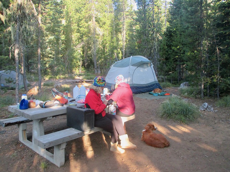
We started our fourth day with a slow and relaxed morning:


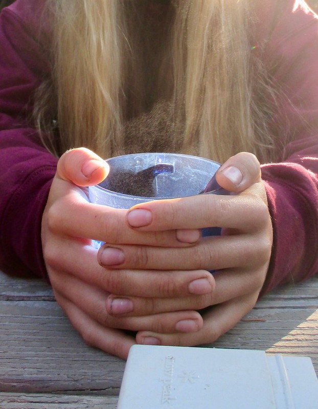
Steam coming from Tricia’s hot chocolate:


Then we had some decisions to make. The terrain and the road situation both change north of Olallie Lake. Plus, a certain 22 year old was driving up to meet us. Should we hike? If so, how far? Where to camp/meet Katie?

Coming up less than four miles from our last end-point was an area where the trail passes up the west side of the Warm Springs Reservation. This area is heavily logged and the dirt logging roads there “change” a lot year by year (even the PCT guidebook mentions this). As best as I could tell, we’d likely need to do 24.6 miles through that area in one push. We could look around some, but it didn't seem likely that we could shorten this. So, for today it seemed logical to hike just under four miles to set us up for the longer leg and then drive north to find camping.

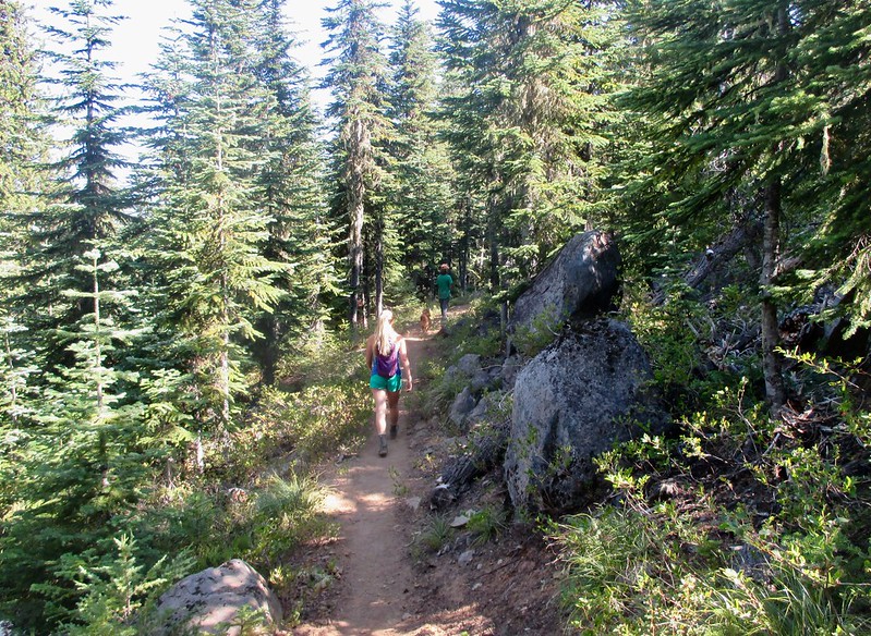
Our less than four miles hike traversed the west side of Olallie Butte on easy terrain:


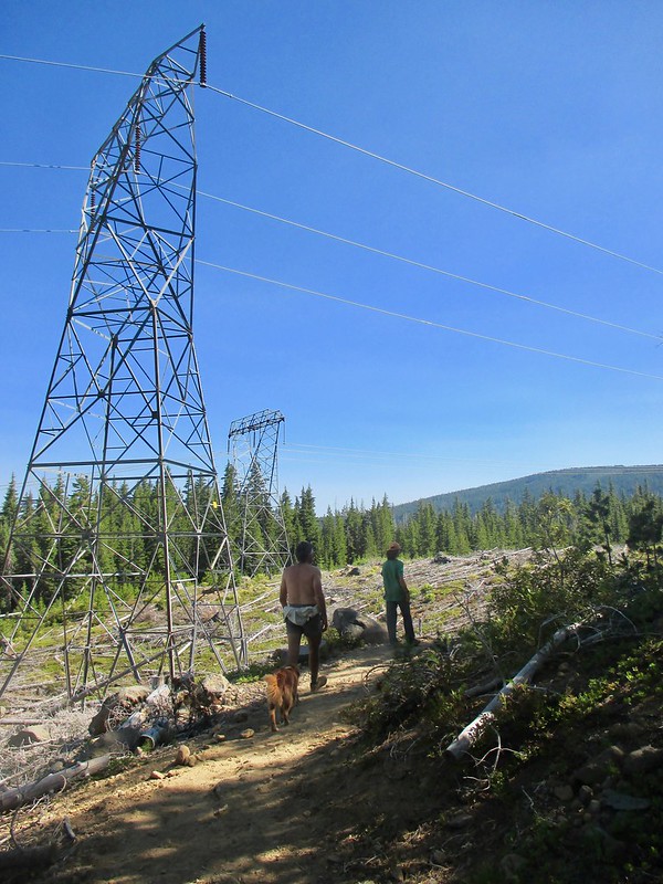
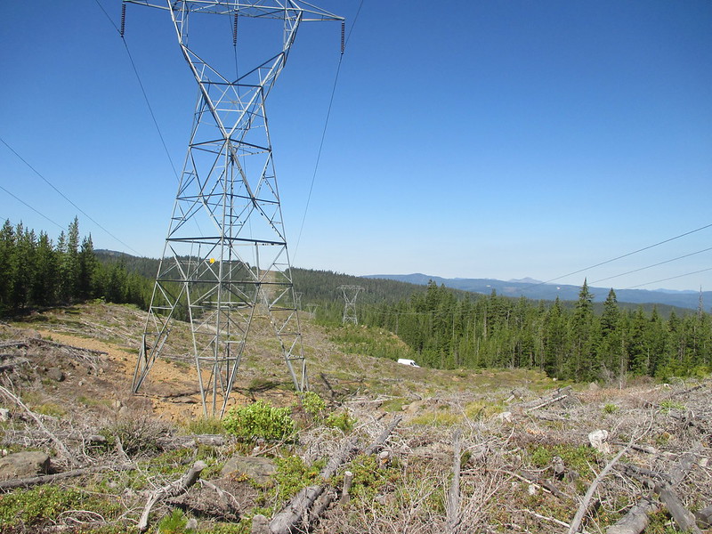
About the only break in the forest was where the trail passed under high tension wires:


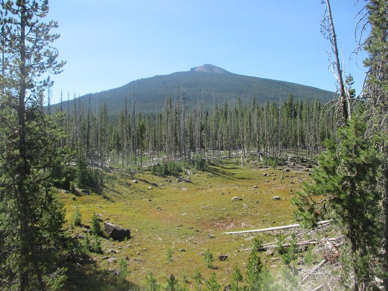
We finished with Olallie Butte well to the south:


A very interesting driving reconnaissance then followed. The maps we had showed possible dirt road pick-up points. We thought we’d check these out and maybe thereby cut the coming, long, 24.6 mile day into two pieces. A discerning reader, seeing the words “very interesting,” might think to themselves: what, in the context of these nut-jobs, do those words mean?

Well, let’s see. How to answer politely…? To start with, the “main” dirt road we took was fine. But then we needed to take a side dirt road. We barely made it. Over three miles Vicki kept it in first gear, four wheel drive and we still barely made it. Dust, bumps, and trees resulted in massive jostling,  many stops and tight turns, and, ultimately, scratches to the Ford and a destroyed right running board. But she did it. She did a masterful job of driving really.

The “quality” of this side road left us with an easy decision too. We made it to a better dirt road and unanimously agreed: no way. No way on God’s green earth were any of us going back there. To hell with cutting the distance down, we simply were not driving anywhere near those three miles again.

That decision made, we had only to find a place to camp. Instead, we got lost. After we got off the really bad road, what was there, in that forest by way of roads, bore absolutely no resemblance to what was on our maps. We tried “dead reckoning,” but in a forest? With a third of a tank of gas, no phone reception and no road signs? Sketchy. We kept calm (mostly).

Half an hour of driving passed. Nothing. I used the InReach to text Steve (Alex’s dad). “Where are we relative to Road 42?” (The InReach sends a message that includes a map link with it - Steve could click on this and then text back some idea of where we were.) But nothing again. Steve got the message, but for the first time in either of our experiences ever, the message did not include a link. Crap again. We kept going, now at least headed in the right direction (northwest, thank you very much).

Finally, we stumbled on the road we needed, paved Road 42 (like many such crises, we went from “oh shit” to “thank God” in about three seconds). Relieved, we continued north toward Timothy Lake and our intended camp. (I’ve never, ever, ever seen maps that are so far off that I couldn’t at least reconstruct where I’d been after the fact - even using Google Earth, the Half Mile and strip maps bear no resemblance whatsoever to what we drove).

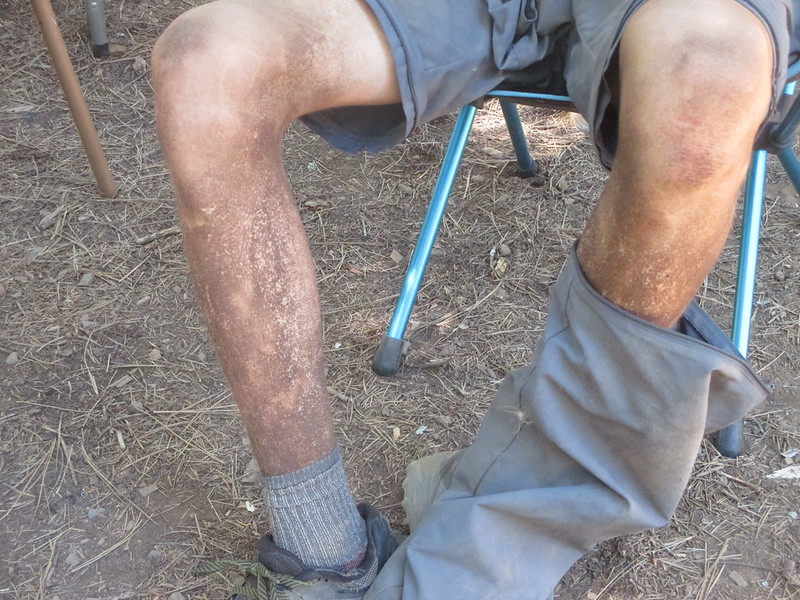
Once there we tried to put together the remains of a rest day. We set up camp. We ate. Katie texted that she’d be there by 4:30. Then it was time to clean ourselves up (Olallie Meadow Campground is dry and we’d gotten there after the three-day backpack short of water). Tricia and I decided to walk over and at least wash off the dust in the lake (we’d been doing what we could along those lines each day). And Alex? Well, Alex is a 13 year old boy. I was one of those once, and, at least I thought, I know what it is like to be completely unworried about getting and staying dirty. After four days though, I thought he must be pretty dirty and ought to clean up at least a little. Vicki and I insisted that he join us in the lake.

Pretty dirty? He wore long pants hiking for four days. When he took them off to go in the lake? Well, I’m at a loss for words; it can’t be described. Here it is:


JC w KC redux

  • Agent Orange
  • ****
  • Posts: 6563
  • my density has brought me to you...
Re: The PCT Volume 36: Very, Very Satisfactory
« Reply #8 on: August 06, 2018, 07:11:26 PM »

I could see that picture coming up as I read but nothing could have prepared me for the shock or the laugh I was about to get  :yikes: :yesnod: :thumbup: :lol:
One wheel shy of normal

Brad Young

  • Grand Master
  • ***
  • Posts: 6664
Re: The PCT Volume 36: Very, Very Satisfactory
« Reply #9 on: August 06, 2018, 07:17:11 PM »
I haven’t hiked more than 21 miles in a single day since I was in my twenties. But none of us wanted to carry full packs for two relatively short days and the road reconnaissance yesterday made it very clear that we weren’t going to cut down the distance (I guess the recon was successful in a way). So we decided to go for the full 24.6 miles in one day. By the end, 24.6 miles didn’t seem all that bad.

Also, to my extreme pleasure, today we’d be joined by a fourth person. Katie has a job this summer guiding backpacking and hiking trips in Yosemite. She loves the job, but, well, Yosemite hasn’t exactly been “open for business” with the Ferguson fire and all. She’d always wanted to check out the Bend area and so she decided to come up and join us for some of this summer’s trail.

Katie got us all up and moving early. We made the drive down from Timothy Lake on the main roads (no diversions and no recons!). We started hiking by 8:15:


A quick 3/10 mile hike got us back to the trail:


And that’s about the extent of the “interesting part” of this hike. Yeah, it was 24.6 miles, but most of that was in deep forest. There were no trail junctions until the end, and so I cut the kids loose to hike at their own pace. Here’s what I saw occasionally:


Mostly though I saw this:


They did wait now and then:


I caught up at Lemiti Creek (a nice looking place to camp, but we only took a break):


And then they were off like a shot again. There followed more hiking in forest (alone). Although mostly "in" forest, we went directly through one clear-cut and got glimpses through trees of others. This made me curious, and, checking later on Google Earth I saw that the whole area is a checkerboard of old and new clear-cuts; the trail mostly stays in the remaining forest, creating only the illusion that the whole area is continuous trees:


Eventually I caught up with the kids again at the only “really nice” place on the hike, Warm Springs River. In spite of the name, the water was very cool and refreshing. We took a nice long lunch:


After lunch we continued north in nice conditions. And I saw something I’ve never seen on a trail. This trail, this PCT was well maintained in this area. Very well maintained. From new erosion banks and log steps to a “re-flattened” tread, the trail had clearly been worked on recently. Oh, and someone had weed-eated (eaten?) both sides of the trail for over two miles. Seriously:


By the last few miles we were all hiking together again. After only 9 1/2 hours we came to our end-point, Road 42 (I’d estimated to Vicki that we’d take 11 hours):


A quick drive back to camp at Timothy Lake then left time for some in-the-lake cleanup, a nice dinner, and some more PCT planning:


Brad Young

  • Grand Master
  • ***
  • Posts: 6664
Re: The PCT Volume 36: Very, Very Satisfactory
« Reply #10 on: August 06, 2018, 07:19:08 PM »

I could see that picture coming up as I read but nothing could have prepared me for the shock or the laugh I was about to get  :yikes: :yesnod: :thumbup: :lol:


His dad summed it up really well. I emailed the photo to him. His response?

"Good lord!"

But dirty or not, the kid had fun (visibly) and hiked like a fiend.

JC w KC redux

  • Agent Orange
  • ****
  • Posts: 6563
  • my density has brought me to you...
Re: The PCT Volume 36: Very, Very Satisfactory
« Reply #11 on: August 06, 2018, 07:36:31 PM »

The look on your and T's face in that first picture made me laugh.
Nice pace!
That shirt must have slowed you down - or I was truly there in spirit.
Nope...no way I could have kept that pace unless you took me back to the days when I was running half marathons.
Weed-eated works for me - I think it is in the new dictionary  :lol:

A quick drive back to camp at Timothy Lake

Timothy...Timothy...where on Earth did you go... :out: :guitar: :blahblah:
One wheel shy of normal

Brad Young

  • Grand Master
  • ***
  • Posts: 6664
Re: The PCT Volume 36: Very, Very Satisfactory
« Reply #12 on: August 07, 2018, 07:33:51 AM »
Our sixth day was an easy 13.1 miles, split into two sections by a visit to “Little Crater Lake” and lunch with Vicki and Katie (Katie’s knee was slightly sore from the 24 mile day, and since her legs are “working assets” these days, she decided not to hike today).

Off from the trailhead:


Next to the Oak Grove Branch of the Clackamas River:


Quickly to the shores of Timothy Lake (the PCT goes halfway around it, on its shores):


Views across to the campground where we were staying:


Soon we leave the trail to hike over to Little Crater Lake. This is an interesting feature that might better be called “Minuscule Crater Lake.” Minus its garage, our house could fit into it. The “lake” is actually an artesian spring gushing 40 degree water. It’s hard to photograph its wonderful teal color and depth. This shot will have to do:


A nice rest stop with Vic and Katie:


And then off again, forest hiking toward Mount Hood and Highway 26:


Forest marching that is until we came around one corner where the trail is high up on the canyon wall of the Salmon River. The trees part and there’s this view:


Nice mountain!

The highway was an easy hike away:


By mid-afternoon we were back to camp and a relaxing afternoon and evening (this “heavily supported, ultra, ultra slow through-hiking" does have certain advantages).

mungeclimber

  • PermaBan
  • ***
  • Posts: 6665
    • http://www.sonorapassclimbing.com
Re: The PCT Volume 36: Very, Very Satisfactory
« Reply #13 on: August 07, 2018, 07:43:59 AM »
I do heavily supported climbing trips. The only way to climb.
On Aid at Pinns... It's all A1 til it crumbles. - Munge

JC w KC redux

  • Agent Orange
  • ****
  • Posts: 6563
  • my density has brought me to you...
Re: The PCT Volume 36: Very, Very Satisfactory
« Reply #14 on: August 07, 2018, 08:56:32 AM »

Looks like my kind of day of hiking but I just can't get excited about forest marching.  :blahblah: :nonod: :nono: :biggrin:
I think you meant to say Artesian spring? - although in this time of foodies - artisan works too.
Did you drink that water? It looks incredibly clear in your picture. I can see some logs and maybe a mafioso or two on the bottom. It sounds like it is a flowing artesian spring, so the lake levels will fluctuate with the water table. I could explain how that all works - but then my hourly consulting rate would kick in and no one would want to pay. Not to mention I would have to shake all of you awake to get you to pay  :sleep: :sleep: :sleep: :sleep: :sleep: :sleep: :sleep: :sleep: :sleep: :sleep:
One wheel shy of normal

Brad Young

  • Grand Master
  • ***
  • Posts: 6664
Re: The PCT Volume 36: Very, Very Satisfactory
« Reply #15 on: August 07, 2018, 09:04:43 AM »

Looks like my kind of day of hiking but I just can't get excited about forest marching.  :blahblah: :nonod: :nono: :biggrin:


Yeah, the only thing that's really satisfying about forest marching is progress toward a goal. I guess it's good exercise too.


Quote

I think you meant to say Artesian spring? - although in this time of foodies - artisan works too.


Yikes. Too much typing before enough coffee (artisan coffee though). I fixed it.


Quote

Did you drink that water? It looks incredibly clear in your picture. I can see some logs and maybe a mafioso or two on the bottom. It sounds like it is a flowing artesian spring, so the lake levels will fluctuate with the water table. I could explain how that all works - but then my hourly consulting rate would kick in and no one would want to pay. Not to mention I would have to shake all of you awake to get you to pay  :sleep: :sleep: :sleep: :sleep: :sleep: :sleep: :sleep: :sleep: :sleep: :sleep:


Didn't drink it, but I put my hand in it to test that is really was coming out at a steady, year-round 40 degrees. And it was.

It's a neat feature, and yes the water is very deep and very clear too. One of the things I like about this long adventure is the chance to see things that we otherwise would never, ever see.


F4?

  • unworthy
  • Posts: 6172
Re: The PCT Volume 36: Very, Very Satisfactory
« Reply #16 on: August 07, 2018, 10:56:31 AM »
While you were gone a few things happened on the Pass.

Nice job!
I'm not worthy.

Brad Young

  • Grand Master
  • ***
  • Posts: 6664
Re: The PCT Volume 36: Very, Very Satisfactory
« Reply #17 on: August 07, 2018, 11:51:33 AM »

While you were gone a few things happened on the Pass.

Nice job!


Unfortunately those "things" are still happening on the pass.

Brad Young

  • Grand Master
  • ***
  • Posts: 6664
Re: The PCT Volume 36: Very, Very Satisfactory
« Reply #18 on: August 07, 2018, 06:54:34 PM »
This day was kinda yin and kinda yang. Highway to highway forest marching for the first half, a break with Vicki, and then an ascent through forest onto the open flanks of a magnificent mountain.

First though this shot from our morning in camp. I gotta admit that this woman looks very, very nice in pink:


Punks and one mature adult at the Highway 26 trailhead:


Then off, together at first, and then me slowly “letting them” get ahead:


To the PCT trailhead on Highway 35:


After lunch we crossed the highway and started up the southwest side of Mount Hood:


The terrain got more and more alpine:


Soon we could see Timberline Lodge:


We met up with Vicki at the headwaters of the Salmon River:


Then hiked the few hundred yards to the PCT exit point (for the day):


And then a miracle happened. At least it seemed to. Somehow, somehow, I'm not sure by what means, we suddenly made another 256 miles (miles!) of progress north from Mexico in the course of less than five minutes walking:


Miracles are a good way to end hiking days. And this one wrapped up our second to last day of hiking. Notice so far the clean skies for days on end, the lack of clouds and the warm temperatures? That’s about to change….

F4?

  • unworthy
  • Posts: 6172
Re: The PCT Volume 36: Very, Very Satisfactory
« Reply #19 on: August 07, 2018, 07:40:21 PM »
Alex did not get the memo on shorts?
Very ballsy to hike in denim.
I'm not worthy.