Author Topic: The PCT Volume 39: Grateful for Anything  (Read 4659 times)

Brad Young

  • Grand Master
  • ***
  • Posts: 6664
The PCT Volume 39: Grateful for Anything
« on: July 06, 2020, 03:52:45 PM »
Maybe it’s the difference between hikers and mountaineers. But hold that thought for now and we’ll come back to it.

The year 2020 has gone weird. No-one who reads this will need an explanation. Tricia graduated from high school. But without any of the things that make the end of that year fun. No track season, no prom, no Disneyland trip. No signing yearbooks. Not even a graduation. No school as we know it for the last three months of her Senior year.

And what of our PCT plans? Who knew in March whether we’d be able to do any PCT at all this year. Our plans for finishing to Canada? Out the door. We’ve been very grateful that our family has escaped any effect from Covid 19 (so far). Hiking on the PCT? It got to the point where we'd be grateful for anything.

We left for our first PCT attempt at the end of June.

We left the house prepared to have absolutely minimal contacts. Gasoline, groceries, masks, careful hand-washing and bandit camping (to avoid people, and, regardless of that, would formal campgrounds even be open?). We thought we’d make exceptions for three friends (more on them later), but otherwise wouldn’t open ourselves to infection and wouldn’t be open to infect.

We split the drive up into sections. Two county highpoints in far northeastern California provided warm-up hikes and got us a third of the way there.

Then to Hood River Oregon. Although we’d finished the Oregon part of the PCT, great friends of ours had recently relocated from Santa Cruz to Hood River. We had to visit Brian and Whitney (and Whitney’s family, who’d we’d stayed with during last summer’s second PCT trip).

Nice house, and what a beautiful town. We spent part of our rest day visiting the Hood River itself:


And then, early on Monday, we drove to and through Yakima, Washington on our way to start again at Chinook Pass, on the eastern edge of Mount Rainier National Park. We saw Mount Adams on the way:


Brad Young

  • Grand Master
  • ***
  • Posts: 6664
Re: The PCT Volume 39: Grateful for Anything
« Reply #1 on: July 06, 2020, 04:43:04 PM »
Day One:


Our arrival at Chinook Pass trailhead caused me some anxiety. Snow doesn’t melt as early in the Cascades as it does in the Sierra. Would we find good hiking conditions? Would we even be able to hike (shades of the June 2017 Crater Lake trip!)? The trailhead area was almost completely snow covered:


Looking back to the southeast, across last summer’s last PCT mile, caused more worry. The north-facing slopes were positively covered with snow! It looked steep in places and very icy. Would the trail ahead of us look the same? Here's a shot of the trailhead and the slope nearby as seen from a mile up the trail:


And although our first three miles of south-facing slopes were snow-free and dry looking, we had 1,000 feet of elevation to gain and then multiple north-facing cirques to cross. Damn.

Well, we’re here. There’s nothing to do but hike up and see what's there is to see. We hiked up toward Sourdough Gap to check things out. The initial hiking was dry and easy:


The south side of Sourdough Gap was snow-free (seen from a distance):


But things seemed to get worse as we progressed. We encountered lots of other hikers. These were all day-hikers though and we didn’t know anything about their experience levels. But still, they’d been to the gap and seen what was on its north side and, so far, we had not. The first two hikers we encountered had made it to Sourdough but turned back due to snow. They had snow creepers with them and hadn’t even tried crossing the north-facing slope. Yikes!

The next couple we talked with had reached the gap and turned back too. They talked about open, steep snow slopes and "one slip" leading to “catastrophe.”

I pictured slopes like the one we could see from the trailhead. And started kicking myself for not at least throwing in an ice axe.

We met another couple. They seemed more experienced. But she’d been unwilling to cross that north-facing snow and they'd turned back. She told us (literally) “the PCT does not exist as a trail on the other side of that gap right now.”

Alright, kick self, kick self. Damn me. Pretty sure by this point that we’d end up just turning around, regrouping with hastily-purchased ice gear at some shop in Seattle, and coming back, we continued on. With less than half a mile left to the top of the gap, why not at least check it out?

As seems normal these days, Tricia finished the uphill before I did. When I got there, I was shocked. Ice? Exposure? Long steep slopes? This is what we found:


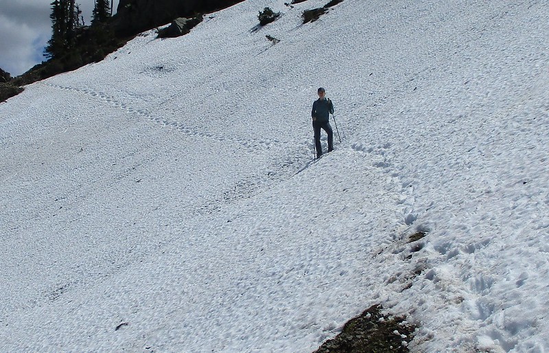
Steep? Sort of. Exposed? Yes, no and maybe. It was a little exposed, but when I walked over to kick the snow (instead of myself) it was soft. It wasn't mushy, “walk-right-across-it” soft, but it was certainly soft enough to kick steps in. And if one did lose traction? Look at the angle - steep yes, to start with. But the angle softens (below the line of the photos) and then the slope becomes flat. All long before there’s anything to hit below. A fall would be scary. But it wouldn’t be particularly dangerous.

Maybe it’s the difference between hikers and mountaineers. We’d done crossings like this. We felt like we knew how to evaluate and handle them. People with less experience saw things differently.

I started across with fanatical caution (meanwhile the dogs romped and slid up and down and all over). Kicking steps and watching my body position, I made the crossing easily. Tricia used her poles and caution and wasn’t ever really worried.

Glad we’d gone for it, this is what we encountered to the north:


Clear sailing. To say the least.

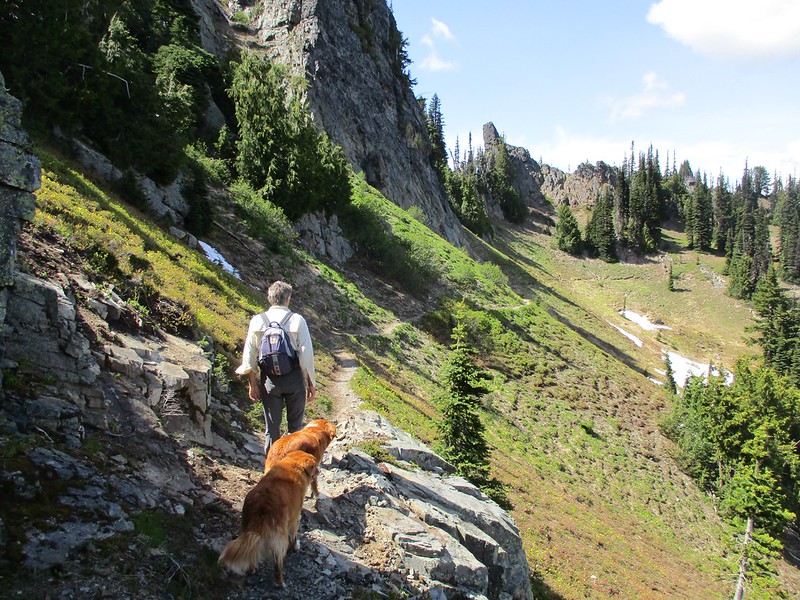
The rest of the day’s hike was wonderful (really the early part of the day was wonderful too - but filled at the same time with a certain level of worry). We had very little elevation change on the PCT itself; ridge-running predominated, first on one side of the crest and then on the other:


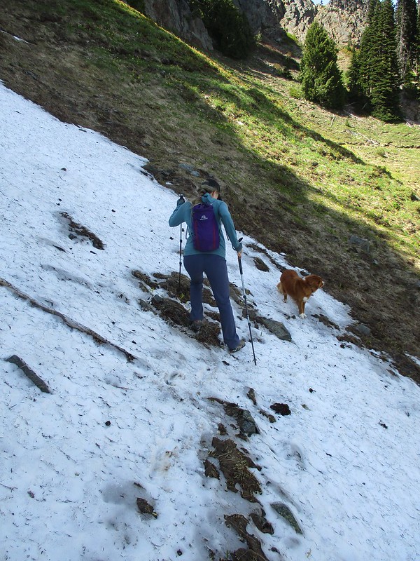
Another snow patch was steep, icy, sustained and had a bad landing. It wasn't very wide though. So we moved down off the trail to get across it safely:


Soon we got a glimpse of Crystal Mountain Ski Resort - our exit point for the day:


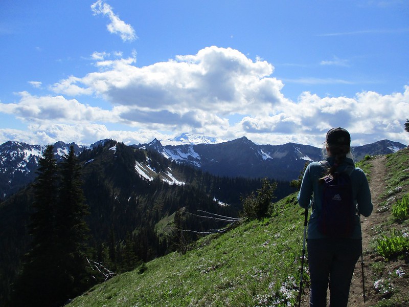
Sometimes we hiked on the crest:
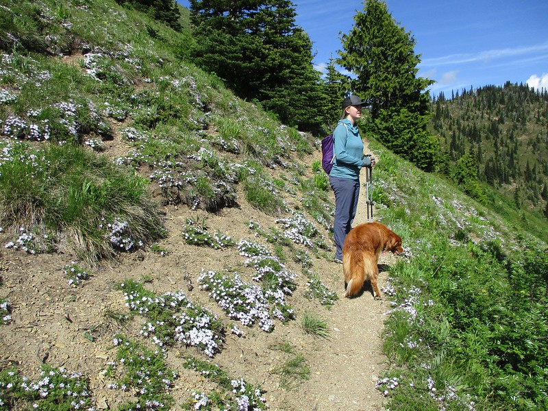


Lots of flowers:


The skies were blue in places, cloudy in others. We had more snow crossings:


And then we came around a corner and got a partial view of this behemoth above and behind the ski area (it's becoming increasing clear why locals tend to call this thing "the" mountain - it is just huge when compared with anything nearby):


One more section of crest before we headed very steeply down Bullion Basin Trail to the ski resort:


We met up with Vicki and did some scouting. We lucked out too and found a close-by, flat, and quiet place to bandit camp:


All in all, our first day made a great start to the season.

Brad Young

  • Grand Master
  • ***
  • Posts: 6664
Re: The PCT Volume 39: Grateful for Anything
« Reply #2 on: July 06, 2020, 06:38:13 PM »
Day Two:


We found the “right” way to start Bullion Basin Trail on this second morning and it saved us 0.4 mile and 150 feet of elevation gain:


It was nice to save that elevation gain too, because the 1,200 feet of uphill trail back to the PCT was really steep:


We gained a coveted view of Mount Rainier from just above Bullion Basin:


Once we were back on the trail that mattered, we could see the ski resort far below:


Our PCT hiking though would again be relatively flat, mostly ridge-running:


Scout Pass:


Early season, still-sprouting corn lily:


Way too much burned forest along today’s section of trail:


Although sometimes burned forest provides room for flowers to grow:


A rather pleased looking selfie:


Little Crow Basin:


Have we covered the ridge-running? Lots of that, but just too many clouds for great, long-range views:


As the guidebook warned, as we moved north, we started to see a stark, checkerboard pattern of clear cuts:


Near mile 18 (for the day), we walked along Government Meadow. Tricia commented back to me about a huge herd of “deer.” I looked. They weren’t deer. They were much bigger, some had huge antlers and there were about 30 of them:


Government Meadow is the home of the Urich Cabin. It’s well acknowledged as the nicest cabin on the PCT. It’s also rumored to be haunted - anyone who harms the forest nearby will, reportedly, suffer (given the huge number of clear cuts nearby one wonders if the haunting is ineffective or ironic). The cabin also serves winter sports people, sitting as it does right on the Cascade Crest. We were impressed at what great shape it was in:


Government Meadow served as an important resting place for an early emigrant party:


Soon we saw Forest Road 7080, our designated “Vicki” point for the day:


It was only a tease though, we had to do another quarter of a mile up hill to reach the part of the road crossed by the PCT:


After our very pleasing second day, we skedaddled to a lower-elevation camp along the Little Naches River. The pass where we met Vicki wouldn’t look or feel the same when we returned to continue.

F4?

  • unworthy
  • Posts: 6172
Re: The PCT Volume 39: Grateful for Anything
« Reply #3 on: July 06, 2020, 08:29:45 PM »
Nice.

I'm not worthy.

clink

  • Meanderthal
  • ****
  • Posts: 4003
Re: The PCT Volume 39: Grateful for Anything
« Reply #4 on: July 06, 2020, 08:40:02 PM »

 Beautiful, even the natural, healthy burned forest.
Causing trouble when not climbing.

briham89

  • Mudders
  • **
  • Posts: 233
Re: The PCT Volume 39: Grateful for Anything
« Reply #5 on: July 06, 2020, 10:06:11 PM »
Great to see you guys! Glad the hiking went well.

Brad Young

  • Grand Master
  • ***
  • Posts: 6664
Re: The PCT Volume 39: Grateful for Anything
« Reply #6 on: July 07, 2020, 07:12:54 AM »
Day Three:


The third day’s drive to the trail started under clouds. And continued into them:


It was 41 degrees when we parked and it was very drippy. Views were out of the question:


The hiking was still mostly level, but we felt like we were in a corridor:


At least clear cuts don’t look as harsh when viewed in fog (arguably):


Of interest were an interpretive sign and an odd, yellowish blob-fungus:


One three hundred yard section of trail was completely under snow. We navigated carefully (Tricia led us through this section):


The fog persisted:


Until it didn’t. But this section of Washington, this forest north of the Norse Peak Wilderness and south of Interstate 90 is both a recreational and a working forest. As the fog dissipated about the only views were clear cuts  (old and new):


And finally, the day's PCT excitement was Vicki’s. She drove around from our drop-off point to Interstate 90. She was to exit the freeway and make her way up to  Tacoma Pass. Every map we had indicated a relatively short drive from the interstate, up Cabin Creek Road. One problem though... Cabin Creek road washed out a few years ago. The wash-out isn’t signed until a driver is on it, miles from the freeway. And nor is it marked on any maps. We finished 16 miles to Tacoma Pass before Vicki could get there. She simply could't find a way through to us. Tacoma Pass? As she has said before, there was “no there there.”

Luckily, proximity to the freeway corridor brings some phone reception. We texted until we actually arrived at the pass and then had no reception. The last message from Vicki was that she was going to head back to the interstate to try again. Tricia and I had only been waiting at the pass for about three minutes when a dirt-biker rolled up. He stopped when we flagged him down. He turned into our savior! The rider, Jim, was local. He knew the roads well. He told us about Cabin Creek Road. And about how to drive from the interstate to the pass.

Tricia ran back up the trail to reception and texted Vicki Jim’s driving directions. Vicki acknowledged (with an exclamation point!). And then we sat down to wait:


Vicki arrived much sooner than we expected (Jim had commented about how long her drive might take). We set up off the road with the nose of the Expedition right next to the PCT itself (we expected no through hikers and, given the “working” nature of this section of forest, and its resultant "unpopularity," no other hikers either - and in fact none came by):


And, to cap off the day, Jim himself even rode back up two hours later to check on poor orphans Tricia and me (he was camped three miles away). He was impressed and pleased that Vicki had made it to our rescue (and we thanked him again profusely).

Brad Young

  • Grand Master
  • ***
  • Posts: 6664
Re: The PCT Volume 39: Grateful for Anything
« Reply #7 on: July 07, 2020, 07:51:49 AM »
Oh, and I'm still waiting on this end for a certain long-haired friend to forward his photos from this trip's last day....


Brad Young

  • Grand Master
  • ***
  • Posts: 6664
Re: The PCT Volume 39: Grateful for Anything
« Reply #8 on: July 07, 2020, 08:24:48 AM »
Day Four:


Today we started hiking directly from camp (note the Abbey Road impression in the second photo):


This was a “milage” day - nothing particularly exciting except making it closer to Canada (we did pass under 300 miles left to the end of the trail today). Clear cuts and old growth alternated in a checkerboard fashion:


We walked mostly in forests, although we crossed occasional open areas:


We got our first view today of the Alpine Lakes Wilderness. This wilderness is across (north of) I-90 and we’ll hike its 70.9 miles of PCT to Stevens Pass on our next trip:


We noticed that Bearpaw Butte had a Mohawk:


Soon we started crossing under a series of high voltage lines. These are close to Stampede Pass, our end point for the day:


Vicki had found a campsite overlooking small Lizard Lake. Although relatively close to the road, the site was so small that there was no possibility of anyone camping nearby (the nearest July 4th weekend camping neighbors were 300 yards away - just far enough so that most of their noise-making was muted by the forest - although that M-80 type explosion in the early evening… not so much):


Brad Young

  • Grand Master
  • ***
  • Posts: 6664
Re: The PCT Volume 39: Grateful for Anything
« Reply #9 on: July 07, 2020, 04:17:36 PM »
Day Five:


Our older girl Charlotte will turn 11 next month. And while all of the enthusiasm is still there, she gets tired. Today she got a rest day:


Vicki walked us back up to Stampede Pass:


More hiking in semi-civilization:


When the railroads were being built in this area (the 1800s), the U.S. Government granted them every other square mile of land. The idea was to give incentive (land/wealth) to pushing the railroad through to the west coast. The railroad companies sold most of their square mile plots to timber companies, who then proceeded to harvest timber. The result still is this checkerboard pattern of cuts:


We passed Yakima Pass and Twilight Lake:


A big climb led past Mirror Lake Creek and its cascades:


Mirror Lake itself is perched up on a plateau, 100 yards from the steep canyon wall. It’s a beautiful lake, although it was way too crowded for our tastes on the Fourth of July Weekend. We kept going to an exit point:


Another mile on the exit trail and we met Vicki (we’d cut an 18-plus mile last leg into two parts so that our friend Dennis could join us on our last day to Snoqualamie Pass).


Brad Young

  • Grand Master
  • ***
  • Posts: 6664
Re: The PCT Volume 39: Grateful for Anything
« Reply #10 on: July 07, 2020, 07:58:37 PM »
Last Day:


Warning to the squeamish: two of the photos in the next installment of this report show one “Mister Mud” smiling. He claims that one of the smiles is fake. That still leaves one that is real. Read the following at your own risk.

We cleaned up camp first thing in the morning and then drove to the trip’s end-point, the north PCT trailhead at Snoqualmie Pass. To meet this guy who lives 40 miles from there and was willing to join us for the day’s hike:


We drove to the trailhead together. We were all masked as an easy and sensible precaution:


It was a holiday weekend at a trailhead less than two hours from Seattle, with great weather and a gorgeous lake only a mile and a half up-trail. Crowded? Uh, yeah. But all the masses spread out as we hiked, and besides, Washingtonians seem to be pretty nice people (yes, even Dennis is included in that comment):


We took a rest after the first big climb:


Snoqualmie Pass is just over 3,000 feet in elevation. None of our hike on this day was over 4,000 feet in elevation. So we were surprised at the amount of snow still on the ground (I think Snoqualmie Pass draws lots of precipitation in, somewhat like a funnel and that includes more snow than the immediately surrounding areas). We were pleasantly surprised that a known and famous Pinnacles climber actually knew how to move over the white stuff:


Closer views of the Alpine Lakes Wilderness off to the north:


Several of the peaks nearby looked worthy:


Pleasant, cool hiking:


As we moved north we inevitably entered some clear cuts:


Interstate 90 makes a huge northward loop to reach Snoqualmie Pass. We were able to see the highway to the right and, later, to the left:


We saw more and more trappings of civilization as we moved further north. We reached the ski resort and walked down its slopes:


Vicki walked over to meet us. As usual, Halifax sprinted to see her:


Traffic wasn’t heavy, but Tricia still improvised a leash for Char (Charlotte’s mostly deaf now and Tricia was worried that if traffic did suddenly appear, Charlotte wouldn’t hear our calls):


Under the I-90 overpass and up to the north trailhead:


The kiosk at this trailhead describes a feature that is well known among PCT hikers - the Kendall Katwalk (different looking, at least from the photos, from the Pinnacles' “Katwalk”). The comments were fascinating and we look forward to seeing this on our next trip:


And the last photos: my tough and smart daughter in her nice, after-hiking, semi-dress sandals. Complete with (close-up) taped sore spots and blisters:


mungeclimber

  • PermaBan
  • ***
  • Posts: 6665
    • http://www.sonorapassclimbing.com
Re: The PCT Volume 39: Grateful for Anything
« Reply #11 on: July 07, 2020, 08:07:21 PM »
Like Mud's hat.
On Aid at Pinns... It's all A1 til it crumbles. - Munge

F4?

  • unworthy
  • Posts: 6172
Re: The PCT Volume 39: Grateful for Anything
« Reply #12 on: July 08, 2020, 04:32:20 PM »
Could have ditched him up there....I would have with a hat like that!
 :o
I'm not worthy.

mungeclimber

  • PermaBan
  • ***
  • Posts: 6665
    • http://www.sonorapassclimbing.com
Re: The PCT Volume 39: Grateful for Anything
« Reply #13 on: July 08, 2020, 07:59:18 PM »
Probably impossible to take him down. Think he only gets stronger the more he ages.

We may have lost the window of opportunity.
On Aid at Pinns... It's all A1 til it crumbles. - Munge

F4?

  • unworthy
  • Posts: 6172
Re: The PCT Volume 39: Grateful for Anything
« Reply #14 on: July 08, 2020, 09:01:41 PM »
Fair point, he’s survived this far...
I'm not worthy.

mynameismud

  • unworthy
  • Posts: 5972
    • Mudncrud
Re: The PCT Volume 39: Grateful for Anything
« Reply #15 on: July 09, 2020, 06:02:56 PM »
Yeah, I like the hat keeps the sun off my head yet lets the breeze through.  Plus I stole it off of a teddy bear.

Nice write up.  Looks like a good trip.   
Here's to sweat in your eye

Brad Young

  • Grand Master
  • ***
  • Posts: 6664
Re: The PCT Volume 39: Grateful for Anything
« Reply #16 on: July 24, 2020, 04:19:57 PM »
Damn, I am not looking forward to this drive again.

I am looking forward to seeing Mister Mud (I suspect not Mister Mudsir though - he's likely working and maybe not even in the Seattle area).

And I'm looking forward to crossing the Alpine Lakes Wilderness (said to be one of the most beautiful wilderness areas in Washington - if it's as gorgeous as the Goat Rocks Wilderness, oh man are we in for a treat).

We might be able to hike nine additional miles north from Highway 2 to a trail exit once we're done with the backpack (to get a jump on the next, 100 mile backpack). And, bonus, the road to the Del Norte County highpoint's trailhead is in good shape and maybe, maybe, on the way home we'll do that one and I'll zero out my list.


F4?

  • unworthy
  • Posts: 6172
Re: The PCT Volume 39: Grateful for Anything
« Reply #17 on: July 24, 2020, 07:20:09 PM »
Safe travels!!!

Please give Mr a mud the sign for hello.
I'm not worthy.

Brad Young

  • Grand Master
  • ***
  • Posts: 6664
Re: The PCT Volume 39: Grateful for Anything
« Reply #18 on: July 25, 2020, 06:45:40 AM »
Gentlemen (and ladies)... start your engine....

Almost time. I'm bored and waiting, but we'll hit the road here soon.

We'll see Lassen and Shasta on the way up today, and dang near pass the Dawsons, who are hiking the last day of their July trip right where John and Kathy last joined us hiking (they'll finish today, 20 miles south of the town of Belden). They'll drive west tomorrow across where we're driving north today.

We've got a good weather prediction and this section of trail sounds wonderful:

"The Alpine Lakes Wilderness showcases some of the most astonishing terrain in the entire Cascade Range: sawtooth ridges, sharp summit spires, ice-scooped U-shaped valleys, and hundreds of glacially excavated lake basins. Small glaciers persist in the Stuart Range and along the high crest between Chikamin Peak and Mount Daniel. Geologically the Wilderness includes a range of rock types representing the volatile tectonic activity along the western edge of the North American continent. Formations include sedimentary and metamorphic rocks associated with micro-continents that slammed into North America some 100 million years ago as well as more recent granitic intrusions. The latter category includes the great 80- to 90-million-year-old batholith of the Stuart Range."


F4?

  • unworthy
  • Posts: 6172
Re: The PCT Volume 39: Grateful for Anything
« Reply #19 on: July 25, 2020, 01:43:08 PM »
Enjoy the trip Brad.
I'm not worthy.